As a measurement, plantable space is the leading indicator of an sustainable urban forest, while overall tree canopy measurement is a lagging indicator.
A loss of plantable space reduces the opportunity for canopy at the local level, meaning at the neighbourhood level. The benefits that the trees provide and protects the whole of a city for shade, stormwater and heat reduction through evaporation. It’s important that those benefits are localized.
Plantable space is tied to developments at completion of development. It’s a measurement as an indicator of what is possible for canopy cover over the lot. We are challenged by not knowing what the finished plantable space looks like at the end of a project, because plantable space is a variance, and is not legislated.
Therefore, to ascertain whether the urban forest is indeed expanding and if development practices are sustainable, we must examine the Tree Protection Bylaw, which establishes a minimum number of trees per lot or 50 stems per hectare, predicated on projected canopy coverage over time. Currently, this concept remains theoretical and lacks empirical backing. Municipal council members should be inquiring about the number of projects that have met the minimum stem count requirements.
The existing Tree Protection Bylaw (21-035) Implementation Manual suggests that a 15% increase in canopy cover within a span of 30 years is feasible by adhering to current urban forestry policies concerning tree protection on both public and private properties.
A canopy target (40%) for the city has been established through a Council Member Motion, COTW, April 03, 2025 in the Draft Victoria OCP 2025, but targets for specific neighborhoods has yet to be established because of a desire by Council to “move away from neighbourhood level plans (Council Member Motion: Urban Forest Canopy).” The motion passed 5 to 3 (Dell, Kim, and Thompson voted against).
Growth is gradual for replacement trees, and any reduction in growth will show up later as a lagging indicator, if we are not measuring the leading indicator of plantable space.
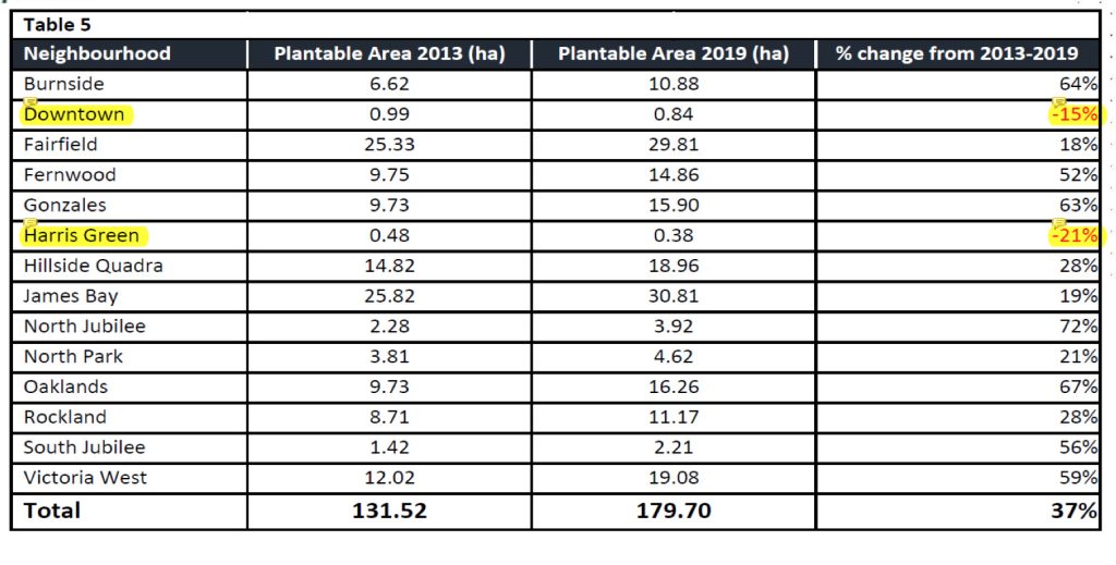
Unfortunately, metrics for plantable space was discontinued in the recent City of Victoria, Vegetation Canopy Change Detection Analysis (2007-2023) by Terra Remote Sensing. However, there is a baseline for 2013 and 2019, and we need to replicate that measurement between 2013, 2019, and 2023.
Through metrics, we can see gains and losses, which are particularly important for equity-seeking neighbourhoods in the City of Victoria. We can see the loss of plantable area/space in the Harris Green (-21%) and downtown (-15%) neighbourhoods (Table 5). We need to ask City staff to request a change order from Terra Remote Sensing to report on Vegetation Plantable Area (ha) and % of change from 2013-2023.
Resources
City of Victoria “Vegetation Canopy Change Detection Analysis” (2013-2019)
City of Victoria “Vegetation Canopy Change Detection Analysis” (2007-2023)
Council Member Motion: Urban Forest Canopy, COTW, April 3, 2025
City of Victoria, Tree Protection Bylaw (21-2023)
City of Victoria, Tree Protection Implementation Manual (21-2023)